Thursday, December 22, 2011

Ten Christmas Gifts A Meteorologist Couldn’t Refuse


Ever wonder what a meteorologist or a weather enthusiast would want for Christmas?  Well I devised a little list for anyone thinking about purchasing a gift for a weatherman, HINT HINT ;) .  ENJOY!
  • Autograph picture of Tom Skilling and Jim Cantore
  • A freaking weather radio, DUH!
  • Video clip of Reed Timmer getting swept up by a tornado
  • A dog that can predict the weather
  • Their very own Doppler radar
  • The movie, Twister
  • Indoor/Outdoor Weather Station
  • A Free Year of the Internet! (How can we forecast without it)
  • Tornado in a Bottle Kit
  • The Weather Channel T-Shirt

Tuesday, December 20, 2011

Unpredictable Wisconsin or Warm California for X-Mas? I know which I prefer.

    I think it is safe to say most of Wisconsin will not see a white Christmas this coming year.  It’s the first year that I have been part of a non-white Christmas since I was a kid.  But if you are living outside the Midwest, what’s it like to have a grassy, green, and warm Christmas?  If you had to make a choice what would it be, Wisconsin or California for Christmas? 

    California.  Beaches, ocean, mountains, cities, people, people, and did I mention people?  One of the largest states, the most populated, and an economy that could keep up with most countries in the world.  What about its geography, ecology, and weather?  Diverse. But what most people think of when California is mentioned is the warm weather---Los Angeles, San Diego, Newport Beach, etc.  Therefore, could you really tolerate a California Christmas?  Average high temperature in Los Angeles in December is approximately 70 F and San Diego is especially close near 66 F.  No way in winter hell could you get any winter cheer from me in that state.  I would have to flee to the mountains in order to get my Christmas spirit.  Sure, if I grew up in that type of atmosphere it would be second nature to me, but growing up as a Midwestern I need me some cold weather and snow. 

    What isn’t there to like about Wisconsin?  Four seasons, varied wildlife, great sports, and friendly people.  One of the best qualities this state can offer is its weather.  Unpredictability is really something we have become accustom to here in Wisconsin and that is why Wisconsin Christmas’s are the best.  I mentioned before, I do not remember the last time I have not had a white Christmas, and it looks like that is in the future for us.  Christmas in Wisconsin can bring us snow, snowstorms, ice, average temperatures, record temperatures, no snow, etc.  Every year seems to be a little bit different.  Not only does this go for northern Wisconsin but this is good for eastern, western, and southern Wisconsin.  Usually if Milwaukee has a white Christmas, so does Madison and Green Bay.  Some years Green Bay will have snow but Milwaukee and Madison won’t.   Anyways, this year brings us a taste of a California Christmas: above average temperatures, different weather patterns, most of the snowstorms have gone west and south of Wisconsin, etc.  With all of these different types of weather, how can you not enjoy Wisconsin for Christmas?

    Warm tropical temperatures versus unpredictability.  Great traditions versus California.   No matter what the weather is, I know where I prefer to be --- here in Wisconsin for Christmas.  But if you want a touch of both worlds for the holiday, head down to Pasadena for a little Badger love.

Saturday, December 17, 2011

Say it Ain’t So, Is That Really Snow on the Ground?

    If you had a chance to look outside on your front porch or lawn this morning you got a pleasant surprise, SNOW!  I also had to pinch myself thinking I was in a dream --- FINALLY some snow.

    A weak disturbance that brought a fair amount of lift to the atmosphere propagated a few snowflakes for southern Wisconsin late last night into this morning.   Most of the accumulation was minimal ---- outside by my house in Shorewood, I’d say we saw close to ½” to ¾” of snow.  But for the most part ½”-1” of snow fell in southeastern Wisconsin.  Higher amounts were associated with a band west and southwest of Madison where they say as much as 3” of snow.

    We could see a few lingering snow showers or flurries this morning in southern Wisconsin.  Eventually, sometime late this morning, that weak system will move off to the east and another weak system will give us another potential round of light snow.   The system will be much weaker and no accumulation is expected.

    Therefore, do not be shocked when you do head outside and see a few small layers of the light and fluffy stuff, that really is snow on the ground! 

Friday, December 16, 2011

Today in Weather History --- Remembering Super Typhoon Paka and Its Path Through Guam


It is a day that everyone in Guam will remember forever.  December 16th, 1997 a catastrophic category 5 “super typhoon”  ripped through the U.S. island territory of Guam bringing along with it sustained winds of 150 mph and had a peak unofficial gust of 237 mph (That 237 mph wind gust was considered the strongest wind ever recorded until a few years ago when it was deemed unreliable) .  The storm dropped nearly 21 inches of rain before the eye of the storm could even reach the coastline making this storm truly unbelievable.

    Paka was a very rare storm formed outside the usual window of tropical storms in the Pacific.  It started out as an area of disturbance southwest of Hawaii, which can be very typical during a strong El Nino year and was eventually formed into the powerful typhoon.  The systems surface pressure sat at a very strong 932 mb and upper level winds were very minimal helping to increase its chances of strengthening.  

    When the storm was all said and done in Guam, the devastation was appalling.  The storm destroyed well over 1,000 homes and buildings and 10,000 were partially damaged.  It left thousands homeless and over $200 million dollars in damage was reported.  Due to the tremendous impact and damage to the region, the Central Pacific Hurricane Center decided to retire the name Paka from the typhoon naming list.  What a day in history!

Thursday, December 15, 2011

What the Hell is Thundersnow?

    I remember last year during a snowstorm here in Milwaukee I saw a burst of light coming from the window.  It was so uncanny I actually got up out of my chair during Sportscenter to see what it was --- heck I figured it was someone flashing a light into the window, maybe a car or snow plow some how flashing its lights eight stories up to our apartment, or perhaps it was some type of UFO deciding to come and pick on “me-lady and I”.   To my astonishment, and well perhaps a quick look in my shorts could tell you what I’m about to tell you, IT WAS LIGHTING and THUNDER!

    So it is winter and we have a nice little snowstorm on our hands and we now have to deal with some thunderstorms --- you might ask how is that possible?   This is a phenomenon relatively new to the meteorology world called thundersnow.   In layman’s terms, thundersnow is a thunderstorm causing snow instead of the predictable rain feature associated with most storms.

    It is a really an extraordinary and rare thing to see and to be quite honest I’ve only seen it a few times in my young lifetime.  You need a couple of weather ingredients to come together in order for this to happen --- strong instability, a lifting mechanism, and an abundance of moisture.   Creating instability in the winter is a very difficult thing to do considering instability can be thought of an air parcel and its ability to rise in the atmosphere from its original position.  For that parcel to rise (a lifting mechanism), you need some sort of lift which leads to either a change in temperature, a frontal system, a large difference in temperatures, etc.  In order for thundersnow to occur, the air at the surface has to be warmer than the air above but not warm enough in order for the snow to melt when falling from the clouds.  Now do you understand why thundersnow isn’t an everyday thing?

    In some incidents, thunderstorms can develop in warmer areas and move off to an area where there is still moisture and potential to create thunderstorms but the temperatures drop just enough in order for the rain to convert to snow creating these new “thundersnow“ storms.  Snowfall rates tend to be higher in areas of thundersnow where it would not be unusual to see an inch or two per hour.

    Now you can go tell your friends you know what thundersnow is and they can ask you, “what the hell is thundersnow”?

Wednesday, December 14, 2011

Wet, Wild, and WARM!


    I was driving around the Milwaukee area yesterday and it dawned on me, it seriously feels like Spring.  In bigger cities after the snow thaws you typically see trash all along the roads/highways, a brownish stain to the grass, people walking aimlessly in athletic shorts while sporting still winter clothes, etc. --- and with the damp, little warm-up we had from the weekend, it really felt like it.  I’m SERIOUS…okay I guess I’m getting a little ahead of myself.

    Luckily, we have a Spring type system on our hands for today as a area of low pressure centralized in the Midwest heads our way today bringing us a chance of…of…RAIN!  If the title wasn’t “wet, wild, and warm” I bet you would have thought I was ready to say the S word.  Actually, this storm system will bring us a lot of rain for Wednesday and in some areas we could see as much as an 1”.  Now for you advocate snow-wanters, that would be almost 10” of the fluffy stuff.   No, no, no, no we do not have to get any snow gear out yet. 

    Heck, some areas will likely see a few imbedded thunderstorms but don’t expect any type of strong to severe storms.  Thunder in December??  I love Wisconsin!

    Along with that inch of rain and a few boomers we will see another significant warm-up where we likely will get into the 50s.  Most of the meteorologist in Milwaukee (or across the state) are not ready to put that on their forecast --- BUT I AM!  HAHA, I said it first (I actually wrote this Tuesday night)! I am staying put for a high of 50 F.  No higher! 

    So, for my early Christmas present to you I “present” a good wet, wild, and warm forecast for you!

Monday, December 12, 2011

Baseball, Weather, and a little Physics!~


    In the midst of the MLB winter meetings and the spirit of baseball thickly in the air, I thought this would be a great entry to make.

    If it wasn’t winter, I would go get my baseball bat (probably from little league) , a baseball, and I would fly out to Denver to prove that I could hit a baseball out at Coors Field.  Okay, maybe I am getting a bit ahead of myself considering I batted left handed all of my baseball career (keep in mind it was pretty short lasting through Babe Ruth) and I personally think I’m a righty hitter. But why don’t more major league players drool over the idea of playing for the Colorado Rockies --- I’ll tell you what, I would!

    Most people probably don’t know, except a few of you physics and baseball minded intellects, that a baseball actually flies farther at higher elevations.  They don’t call Denver, CO the “mile high” city for nothing.  I mean it makes sense right?  Less air, less pressure, less density the ball has to travel through which ultimately means the ball flying a little bit FARTHER then it normally would at regular elevation.  

    Heck, imagine some of those warm, humid June baseball nights you’d be able to play there. In those circumstances the ball would travel even FARTHER then it would say in early May.   When the air heats up, the air density actually decreases helping the trajectory of that ball stay up in the sky a little bit longer.  And we haven’t even mentioned humility factor.  Humid air is less dense then dry air so that means when the ball is hit in humid weather it would go travel even FARTHER!

    When you take all those factors into play, the ball actually travels about 10% farther at locations like Coors Field then it would at a stadium at sea-level.  Booyah!  That’s what I would say after I put the sweet part of the bat on the ball at Coors Field.  Heck if I was lucky, I would get it out of the infield!  10% of 100 feet is………10 extra feet! Let’s not judge here cause I welcome any takers at a good old fashion home run derby. This could be fun --- but we’ll leave the fun to the professionals for now and I’ll continue flipping that weather coin!

    And on the Ryan Braun subject --- I believe he did not do PED’s but he’ll still be suspended…what does that  mean?  I don’t friggen know!

Sunday, December 11, 2011

When was the last time IT WAS THIS COLD~?!

    We’ll have to go all the way back to last February the last time we saw really cold low temperatures. Put it this way, when I bring my dog out in the morning he usually takes his sweet ass time outside ---well he did his business and flew in the house this morning.  Heck, if it wasn’t so cold out I might have had an accident from pure shock of him coming in so quick.

   ANYWAYS, most areas in Wisconsin Saturday morning woke up and saw there first single digit lows of the season (in specific southern Wisconsin).  Milwaukee saw a low of 9 F and places up in Beaver Dam and Reedsburg, WI saw temps anywhere from 5-8 F.  Per the National Weather Service, “The last time minimum temperatures dipped into the single digits occurred on February 11, 2011 and February 27, 2011 for the Milwaukee and Madison areas, respectively”.

      Thankfully, things will be warming back up to above normal and we’ll see highs around 40 F through Tuesday.   We might have a big surprise for you come mid-week, STAY TUNED!

Saturday, December 10, 2011

EnJoY --- It’ll be the last time you see this UNTIL April 2014!

    Who doesn’t like a little Mother Nature show?  If you are like ME hopefully you had a chance to head outside this morning to check out the lunar eclipse.  Well, if you were lazy or if it was your only available day to sleep in, you won’t be able to see another FULL lunar eclipse until April of 2014.

    For those of you who forgot what a lunar eclipse is --- it is when the moon passes behind Earth so that the Earth blocks the rays from the sun.  I highly recommend them, they are pretty darn cool!

Friday, December 9, 2011

Please Tell Me this Is A Joke! ---Where is all the SNOW?

 
    I’m beginning to wonder if people think this is a joke!  It is December 9th and we have yet to see a significant snow storm (or really any accumulating snow) here in the Badger State.  For most of you, this is probably very enjoyable!  But for others they want to get those snow blowers a test and their snowmobiles a ride!

    In Milwaukee, by early December (on average) we have our first snowfall of over 1” and the same with Madison where typically we see this November 18th.   Green Bay has there first snowfall a little bit earlier then Madison.  But nonetheless, remember it is already the 9th of December and no snow! 

    When will we see a snowstorm?  According to a few Numerical Models put together by the National Weather Service, our next shot for snow will be next Thursday into Friday.  Now depending on the route of the storm we could see our first significant snowfall associated with a very strong low with a lot of precipitation to be had.  As of now, it looks most of southern Wisconsin will see rain to start and eventually changing over to snow.   We do have to keep in mind this storm is almost a week out and things could change dramatically by then.

    After next weeks storm, it looks very quiet until Christmas Eve where we could be shoveling ourselves out in order to get around for the holiday.   I would be okay with a little bit of snow for Santa to navigate through.  Let’s keep our fingers CROSSED!

 So if you are still waiting like me, just get the joke over with Mother Nature and let us see some snow!

Wednesday, December 7, 2011

2011 Wisconsin Tornado Season ends in Record Books!!!

 
    Tornadoes!  Almost everyone’s favorite weather related subject!  Wisconsin isn’t necessarily known for their severe weather but some years can change prospectives.  The 2011 severe weather season was a very active year for the state of Wisconsin, started out with a big bang, and ended as the 4th busiest tornado season on record.

    April 10th was the busiest Severe Weather day of the year in Wisconsin.  It all started out with a strong warm front that pushed northward into northern parts of the state.  Temperatures soared into the 80s, we had very unstable conditions, the right amount of wind sheer and CAPE (convective available potential energy), and a approaching cold front/low pressure area that helped generate thunderstorms by 3 pm.  Most of that State (excluding SE Wisconsin) were under Tornado Watches.   By days end there were 15 tornadoes, which set a new record for the most ever on a April day.  The strongest tornado was a EF-3 tornado near Merrill.

    The 38 tornadoes that touched down in the Badger State put this years total at number four all time for most tornadoes in a year, tying with the 2008 season.   Keep in mind that these tornadoes occurred on ten days: April 22nd, May 22nd, June 8th, June 19th, June 21st, July 1st, July 19th, August 8th, August 19th, and August 23rd.   Most of these tornadoes were on the weak side---13 EF-0’s and 17 EF-1’s.  Unfortunately, there was one fatality this year related to the tornadoes in Marinette County when an older gentleman’s oxygen machine shut down due to the loss of power.

    Now that we can safely say that the 2011 Tornado Season is over, what will 2012 have in store for us as we approach Spring?  All I know is we'll always be able to look back on the 2011 Tornado Season as a season to remember!

Monday, December 5, 2011

Coldest Weather of the Season Heading Our Way!!

    You thought Winter started because of a few snow showers and the arrival of Christmas music didn’t you?  False.  In other words, enjoy the next two days because the coldest weather of the season will wonder our way.

    A cold front will sweep across the area helping to drop temperatures well before normal.  This cold arctic air will drift into Wisconsin by mid week bringing nighttime lows into the teens, a few spots could see single digits.  By Thursday, the arctic air will plunge southward and Friday looks to be the coldest day of the week.  Milwaukee and Madison will be in the mid-20’s, Green Bay in the low-20’s, Eau Claire/La Crosse and Chicago in the mid-upper 20’s. 

    No significant precipitation is expected this week since we’ll have northwest winds and dry conditions --- lakeshore communities will see lake effect snow today and tomorrow.  Nothing more then an inch of snow will be expected in those areas. 

    Once we get through this cool spell this week, by early next week we’ll see a warming trend and temperatures again above normal for this time of the year.

Friday, December 2, 2011

Snow Track Changes, Still Full Force Ahead


    Let’s be honest here, it is December and in meteorology that means nightmares for predicting snowfall and tracking.  The last two days, the tracking storm set for this weekends arrival looked to make a bulleyes right in the middle part of the state encompassing Madison, Green Bay, and the Fox Valley BUT things have changed.  The scouting or I should just say straight up stalking of this storm I’ve been doing the past few days has put me in again another predicament --- stay with yesterday’s forecast or go with the new models that have changed everyday now?

    NAM and GFS numerical models are forecast models used to help determine conditions of weather for a particular day and give insight clues for meteorologist so they can accurately forecast for upcoming days.   Both NAM and GFS models are much different for the snowfall locations and accumulations.   At this point I am leaning more towards the GFS since they have been a little more consistent which ultimately means a line of snow can be expected anywhere north and west of Highway 151 in Wisconsin.   Again the most accumulations looks to be in the Marathon County area. 

    Both models will have a new forecast out in a few hours --- until then keep those shovels handy!

Thursday, December 1, 2011

Wind Reports from Tuesday --- Snowfall for Today, this Weekend


    Tuesday, November 29th, much of Wisconsin (especially Southeastern Wisconsin) experience some very strong wind associated with a storm system situated in the Ohio River Valley.   Peak gusts in Milwaukee, Racine, and Kenosha were all above 50 mph!  A wind advisory was issued for most of SE Wisconsin with the tight pressure gradient and lakeshore communities were hit the hardest.  No damage has been confirmed from these winds.

    It looks like most of Wisconsin will get its first snowfall of the season this week and weekend.  Thursday night and into Friday parts of northern Wisconsin including Wausau, Stevens Point, and Green Bay could all see anywhere from a trace to a few inches of snow.  The southern tier of the state will only experience a few flurries or snow showers ---the biggest reason is lack of moisture!  High pressure will settle in nicely and give us a great day on Friday but this weekends storm could give us a better chance of snow.  This storm system will be significant as portions of Wisconsin, anywhere north and west of highway 151 could see accumulating snow.   Green Bay, Fox Valley, and parts of Madison could see 2”-4” out of this system but the Milwaukee Metro could see up to an inch or two of snow where they will see rain to start.  By Saturday night all the rain will switch over to snow and places like Wausau, Eau Claire, Rhinelander, La Crosse, and Iron Mountain could see near 6” of snow out of this system.  Since it is still a few days out those numbers are still well up in the air and we’ll have a much better idea come Friday and early Saturday. 

    Make sure to get those shovels ready, snow blower’s serviced, and your tires chained because we could have a fun weekend on our hands!

Wednesday, November 30, 2011

“Stench of Short Days, Fridge Nights should still keep us Jolly”

    The delights of tripping over stinky boots, searching endlessly for foul jackets, and picking up the flashlight to let the dog out at 6 pm is upon us.  Welcome to Winter in the Midwest!  As November wraps up and December creeps in, we slowly forget those warm, mild summer nights and begin to see another asinine Winter ---whom will mock all winter apparel and equipment we may have. 

    What do you think of when we say the word Winter?  Most of us might think of snow; maybe shoveling or winter driving.  Others may see cold weather; breath being seen or fingers turning purple as the family car is not starting.  For myself, the biggest thing I miss is lack of sunlight and long, mild nights.  How depressing does it get when you go to work/school in the dark and you return from work/school in the dark?  What about the fact that the temperature is about the same when you get home at night then it was when you left that morning?!
   
    Beginning on December 1st, sunrise is at 7:04 am and sunset is around 4:18 pm ---that gives us a total of 9 hours and 14 minutes of sunlight!!!  I do complain about this BUT how about living in Barrow, AK right now?  A week ago (November 18th) they saw the last flicker of sunlight until January 23rd!  Imagine going two months without seeing any sunlight, sunrise, or sunset?!  On top of that their average temperatures in December are below zero and it only gets worse in January and early February.  Maybe that is why there are only 4,000 people that live there, most of them not by choice.

    What about Yakutsk, Russia, located about 300 miles south of the Arctic Circle, is the coldest city in the world.  It inhabits around 200,000 crazy, stubborn people who do not want to leave their city in search of warmer pastures.  Instead they choose to deal with temperatures that get so cold that their advised not to wear sunglasses on certain days because the friggen sunglasses freeze to their cheeks!  Back in 2008, Yakutsk was in the news after a chain of burst pipes caused Artyk and Markha, two villages near Yakutsk, to lose heat for a number of days. The temperatures then were minus 50C. TV footage of the BIG FREEZE showed cliques of people huddled in bundles of blankets gathering round makeshift wood-fired stoves to keep from freezing to death.  How about those apples?

    In January, when we are complaining in our own rights about Winter, remember Barrow, AK has not seen light in months, and Yakutsk gets to deal with average highs around -40 C!  Even though we think these short days, fridge nights are bad, perhaps here in the Midwest during Winter we should still stay jolly!!!

Monday, November 28, 2011

Cool, Cloudy Conditions for Cyber Monday---Storm Brewing for Sunday!

 
     As we are approaching the peak of shopping for Christmas, here in Wisconsin we are yet to see any significant snowfalls or winter weather yet.   Cyber Monday will not be any different!  If you are heading out and about for this Cyber Monday (haha), online shopping or online gifting, conditions look around average for this time of the year.  Highs will remain in the upper 30s today with primarily cloudy conditions.  The main weather maker is an area of high pressure centralized over much of the Midwest which will give us some fair conditions but will quickly move out of the area today as a storm quickly develops to our southeast.  This will give us a chance of some rain tomorrow along with extremely windy conditions.  Temperatures tomorrow will be a tad bit warmer with highs in the lower 40s but winds from the NNE could exceed 40 mph.

    Keep an eye out next Sunday as Wisconsin could see their first significant snow of the season!!!  How much snow, when and where will the storm strike?  I'll talk about that in my next blog entry on Wednesday!

Be Great, Chris!

Tuesday, November 22, 2011

Rare Tornadoes in Wisconsin--- Nov 22nd 2010

Wisconsin does not see Tornadoes very often in November but last year this proved to be incorrect.  Four tornadoes struck the southeastern Wisconsin area and caused significant damage in Walworth and Racine counties.  It all developed under extremely unusual circumstances as warm moist air creep-ed up to the north featuring 60s in Wisconsin and even some 70s near the border of Wisconsin and Illinois.  This was all packed with a very strong jet stream aloft, a storm system, and a winter-like cold front.  No fatalities were reported thankfully but there was damage reported in both counties from the EF1 tornadoes. 

Once the storm system moved away temperatures dropped off significantly from 60s and 70s on Monday down to 20s for lows on Tuesday morning.  In Wisconsin ANYTHING can happen!

Thursday, November 17, 2011

Opening Weekend of Hunting: Your Weekend Weather Report

                                                                 GFS Model for Storm

                                                            NAM Model for Storm

One of the best seasons of the year, Saturday marks the opening of gun hunting for whitetail deer in Wisconsin.  This years forecast was looking quite gloomy earlier this week but things are looking a little better for this weekend.  Tomorrow we have a warm front approaching us from the west that’ll bring us southwesterly winds to help warm us up back into the 40s across the state.  But the storm system I mentioned earlier on this week will be threatening the Badger State this weekend beginning on Saturday in the western part of the state and Saturday night in northeastern sections of Wisconsin.  The best chance of accumulating snow will be in northwestern and north central areas where we could see anywhere from 3-6”. 

    My forecast for the Crivitz (Green Bay) area this weekend where I’ll be heading is:

    Friday: Partly Cloudy Skies and much warmer as that warm front moves into NE Wisconsin.  Highs will be reaching into the mid to upper 40s with a strong southwesterly wind that will gust at times to 30 mph.  If you have some last second preparations in the woods, it should be a gorgeous day to do so!

    Friday Night/Saturday Early Morning Hunt: Becoming Cloudy after midnight as our dynamic storm system begins to develop out towards the Rockies and swing on our way.  Lows will drop off rapidly into the low 20s, and some spots will get down into the upper teens.  Make sure to dress warm but a pancho or rain coat will not be needed YET!

    Saturday: Rain will begin to develop in the afternoon and eventually will switch over to snow as the storm system moves off towards the NE.  I highly recommend bringing rain gear out with you for the afternoon, it will be CHILLY!  Highs will reach the low 40s and will begin to drop by the afternoon.

    Saturday Night: Eventually all rain will switch to snow, some areas could see accumulating snow depending on how far east and south the storm system tracks.  Lows will be in the upper 20s.

    Sunday:  Some lingering snow showers in the early morning but that system will speed on off and we’ll see clearing by mid morning and ultimately sunshine by the late morning and afternoon hours.  Highs in the mid to upper 30s. 

    Good news for you hunters---If you’ll be hunting anywhere north of Highway 29 this season you should see some snow by Sunday morning for your hunt.  That should get those deer moving.  GOOD LUCK AND BE SAFE!!!

---Be Great, CHRIS!

Wednesday, November 16, 2011

Forecasting for Opening Day of deer hunting can get you hurt!


    There are a number of reasons why I chose to get in the meteorology profession: challenge, change, presentation, and just the overall love of weather.  But one of the harder parts of weather is trying to match up a good forecast for friends and family when an important event is coming up!!  No, I’m not talking about Thanksgiving or Christmas, how about Opening Day of Deer Hunting in Wisconsin?!  Every year (or almost) I head up to Athelstane, WI for a great weekend of hunting, food, and hospitality.  I have one job at Buck Camp and that is making sure we have good weather.  Is this the year I end up sleeping outside?

    Last year most of Wisconsin had outstanding conditions for deer hunting as we had a few inches of snow on the ground in extreme northwestern Wisconsin near Ashland and Superior.  The rest of the state saw temperatures in the 30s (far north), 40s (central and south), and even a few 50s in southeastern Wisconsin.  It was really an ideal day to be out and enjoying one of the best days of the year if you are a avid hunter.  I can remember each year heading up to Athelstane and every year being a little different weather wise.  Some years we had snow on the ground and could see our breath where other years I had to start removing layers half way out to my deer stand. But this years forecast looks MUCH different then last years.  So different that if I had my Dad, my Uncles,  one of my cousins, or “the President” (who love to hunt) asking me on the way up to Deer Camp what the weather was going to be like for this weekend, I might as well have them drop me off on the side of the road!

    Since we have established our weekends weather will suck and before I get into that yucky preliminary forecast, we must ask what would be optimal weather conditions for opening day of deer hunting?

    -Snow on the ground (only a few inches)
    -A light wind
    -Cooler temperatures BUT not fridge (20s-30s)

    It is highly unlikely we see any combination of these conditions this weekend. This weekends forecast as of now is setting up for a big storm as a vigorous area of low pressure is headed in our direction and we could have a complete washout for the weekends hunt.  Associated with this storm we could see very strong winds, heavy rain, and even some of that white stuff. Again, by all calculations it will be rain but there is a STILL that small chance the area of low pressure stays more south and that would mean good news for northern Wisconsin, more SNOW!  We’ll keep this forecast wide open for now as that gives me the best chance of staying on the good side of this years Buck Camp.


---Be Great, Chris!

Tuesday, November 15, 2011

Forecast for Southeastern Wisconsin


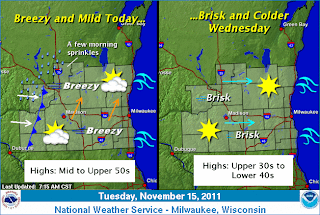
Hold on to your hat today!   We'll see a very gusty southwesterly wind component associated with a low pressure system heading off to our north, there is a potential to see a Wind Advisory posted for Wisconsin with gusts exceeding 40 mph.  A cold front will pass through the Milwaukee area later on today making things very chilly for the next few days.  Highs will struggle to get out of the 30s especially to the north while lows should stay in the mid to upper 20s.  Our next chance of rain will be over the weekend as gun hunting season opens.  A warm front will speed on through from the west on Friday bringing along with it a strong low pressure system that will give us a very good chance of rain and depending on the tracking of the storm the northern parts of Wisconsin could see some snow out of this.  I'll be heading up to the Athelstane-Crivitz area over the weekend for some hunting and crossing my fingers for some snow!

--Be Great, Chris!

Saturday, November 12, 2011

Maybe Winter Really Isn't that Bad?


        Looking back at this warm Summer, I cam remember three things distinctly!  One, where did the summer go?  Second, I was tired of seeing my thermostat at 93 F! Third, where is Winter? Yes I may be stubborn and cheap but taking out my only air conditioner and exchanging it for cooler weather come Fall/Winter is my favorite time of the year.  It makes Wisconsin one of the best places in the United States to live for so many reasons, right?   Well some people may beg to differ!

    Wisconsin truly is unique in its landscape, seasons, and weather.  We are lucky enough to be provided with a vast amount of seasonal patterns and we are getting into many peoples’ favorite (sarcasm), WINTER!  Last year, it was a busy season for snow as Milwaukee and Chicago were pulverized with one of the worst blizzards on record as we come to know it by the “Groundhog’s Day Blizzard”.  Green Bay had three snowstorms of > 12” and we know about the rest of Wisconsin.  Myself, after that huge Groundhog’s Day blizzard, was FOR SURE never ever wanting Winter again but here I am patiently awaiting to throw a few snowballs and watch my dog learn how to eat snow.

    But without Winter, wouldn’t weather and your lives in general be boring?  Imagine Christmas morning without the snow, or not running around obnoxiously outside during the first snowflakes of the season, or as a kid after a big snowstorm awaiting the name of your school to be announced closed!  Ask people in Seattle, London, or even San Diego if they enjoy their weather?  Where would all our cold season traditions and hobbies go?  Would we like hunting in shorts, capsized ice shanty‘s, snowmen without snow, or no faint snowmobile noises in the distance?  What would Lambeau Field and tailgating be without the cold?  Just another stadium in the NFL.

    So this season, as we approach yet another Winter and we begin to dodge other vehicles on the road during our first snowfall, do not ask where Summer is, just realize----HEY, Winter really isn’t that bad!

----Be Great, Chris!
  

Friday, November 11, 2011

You Called That A Storm? --- Great Lakes Storm of November 1913

If you remember this storm system, MAN you're old!  The Great Lakes Storm of 1913 went down as one of the worst U.S. winter storms on record occurring in early November.  This freakish storm was caused by a convergence of two storms over the warmer waters of Lake Superior that generated winds as high as 90 mph and 35 foot waves.  Later known as "The Storm" or "The White Hurricane", she unleashed a type of fury rarely seen on Earth with blinding rain, sleet, and finally snow which lasted in some spots 18 hours (To put that in prospective a good snowstorm lasts 6, maybe 8 hours).   Also, famously this storm sunk five ships that were never recovered and seven other ships were sunk but eventually recovered after search.   When the storm finally let up on November 10th, the cleanup was unspeakable with snow totals reaching > 24", millions of dollars in damage, and around 250 were killed.

What can we do to prepare ourselves for a once in a century type storm like that?

---Be Great, Chris!

Thursday, November 10, 2011

Snow Totals in NE Wisconsin

Snow totals from yesterdays snowstorm.  I cannot believe it is November already!  According to the National Weather Service in Green Bay, "Power outages were reported in Oneida, Marathon, Langlade, Waupaca and Shawano counties as the wet snow caused tree limbs to break.  At the height of the storm, over 15,000 customers were without power.  Hundreds of vehicle accidents occurred across the area."

---Be Great, Chris!

First Snowstorm of the Year

For some of us, winter has finally arrived!  Portions of central and northeastern Wisconsin were blanketed with their first snowfall of the season and it came with a price ----SHOVELING!  Portions of Langlade County in Northeastern Wisconsin were hit with over a foot of snow.  Antigo had reports of 14" of snow, Pearson received nearly 8.5", and Stevens Point had as much as 5" of snow fall in their area.  A more exact amount of snow will be sent out when storm reports are sent in as the morning progresses.  Southern Wisconsin was not hit as hard, areas around Madison (Columbia, Western Dane, and Dodge Counties) all reported around 1-3" of snow.  The Milwaukee metro was hit strictly with rain and a fresh blast of cool air off the lake.  

Here are the snowfall totals from Southern Wisconsin --- http://www.crh.noaa.gov/news/display_cmsstory.php?wfo=mkx&storyid=75056&source=0

The weekend looks gorgeous as a warm front approaches us from the west bringing us highs Saturday in the 50's under mostly sunny skies and more rain headed our way on Sunday with highs around 60!

---Be Great, Chris!

Wednesday, November 9, 2011

NE Wisconsin Snow Update

Northeastern Wisconsin is experiencing their first snowfall of the season!  GFS snowfall model suggesting 1-3" at most while the NAM is advising 3-6" of snow.  Evidently since we are seeing snowfall already this morning the snow totals will be much higher so I'm in agreement with the NAM on snowfall totals.  Keeping in mind it is very difficult to forecast snow totals so early in the year because of temperatures and warm ground but the tracking of this storm looks to bring the first significant snowfall to NE Wisconsin.  
The link to the NAM snowfall total model http://wxcaster.com/gis-snow-overlays.php3?STATIONID=GRB

Monday, November 7, 2011

Green Bay Area Weather

The forecast is still somewhat far off with this system, but Green bay could be under the gun for potential snowfall depending on the track of this low pressure system.  If this system dips to the south, strengthens, or additional cold air is funneled we could see accumulating snow.  As of right now, the models are not consistent enough for placement of the low so keeping an eye on the weather is key.

NWS update (MKE area)

http://www.crh.noaa.gov/wxstory.php?site=mkx

Week of November 7th Weather

Good Evening,

What a wild few weeks of weather!  We've seen the same format of Fall type weather the past few weeks which include a warm front, a day of rain, a cold front, and a cooling trend before the weekend turns nice.  This week won't be much different.   Although today in Milwaukee we only reached 57 degrees because of clouds that lingered into the afternoon, we still did see an overall nice day.  Well, things will be changing significantly!  The National Weather Service has just issued a Winter Storm Watch for north and western parts of Wisconsin with as much as 6" of snow possible.  Milwaukee will not see that kind of winter weather yet, but we are likely to see abundant rain fall with as much as 2-3" of rain in some locations heading into Monday night, all of Tuesday, and portions of early Wednesday.  A cold front will push across Wisconsin dropping temperatures into the low 40's midday and around 30 Wednesday night.  Thursday and Friday, temperatures will be in the upper 40's before another warm-up returns on Sunday with highs around 60 degrees! 

Have a great week!

Chris